The Global Positioning System, also known as GPS, is a United States space-based radio-navigation system that provides users with position, navigation as well as precision timing information.

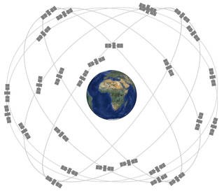
The GPS constellation is comprised of at least 24 U.S. Government Medium Earth Orbit (MEO) satellites that orbit the Earth at an altitude of approximately 20,000 kilometers. Photo credit: Image courtesy of nasa.gov
The GPS system is owned by the U.S. Government and operated by the United States Space Force to meet government defense, civil, enterprise, and scientific needs. GPS currently provides two levels of service: Standard Positioning Service (SPS) and Precise Positioning Service (PPS). The civilian SPS is available to all users on a continuous, worldwide basis, free of any direct user charges. Access to the military PPS is restricted to U.S. Armed Forces, U.S. federal government agencies, and selected allied armed forces and governments.
GPS satellites provide users around the world with a host of services on the ground, in the oceans and up in the air. Here are just a few examples:
Position and Navigation Services – GPS satellites are able to locate or position a GPS device or receiver (e.g., cellular phone, mobile tablet, or turn-by-turn navigation device) by having a minimum of three GPS satellites within range of the device at any given moment.
GPS III Constellation Update – The next-generation GPS III satellite constellation is already being deployed. GPS III satellites are three times more accurate than the current constellation and have up to eight times improved anti-jamming. GPS III satellites are also the first to introduce the new L1C civil signal, which will enable interoperability between GPS and international satellite navigation systems. As of early 2024, the first six GPS III satellites have been launched and the seventh satellite SV-07 is expected to launch later in 2024 or early 2025. A total of 10 new satellites will eventually make up the new GPS III constellation.
Mobile Phone Backhaul Services – Mobile phone companies may often use VSAT satellite terminals to provide backhaul support for restoration of cellular and text services. Satellites can be used to transmit data from a cell tower back to the central network, if wireless, fiber or microwave transmission is not available.
The GPS three-dimensional position location data provides users with wide variety of uses. Please see the list below:

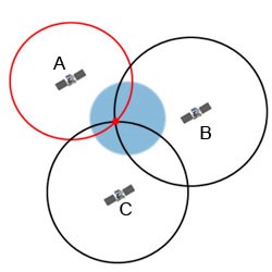
Each of three or more GPS satellites will transmit its location coordinates to the receiver on the device or terminal. Once the distance from the satellites is measured, the GPS device can then calculate the device’s precise location on the Earth’s surface.
This done through trilateration and the more satellites (greater than three) that are used means the more accurate the position data (Photo credit – Image provided by physics.org).
- Automobile Turn-by-Turn Navigation – Automobile navigation systems use GPS position data and integrate it with systems that display mapping or location information on display screens found on dashboards or mobile devices.
- Agricultural Navigation – Precision Farming was developed using GPS position and location-based information for tractor guidance helping eliminate overlapping and missed spots. GPS also assists farmers with farm planning, field mapping, soil sampling and other agricultural applications.
- Marine Navigation – Mariners use GPS data for navigational hazard location and mapping. Commercial fishing fleets also use GPS to navigate to optimum fishing locations, track fish migrations, and ensure compliance with maritime regulations.
- Aviation Tracking and Navigation – Aviators around the world use GPS to increase the safety and efficiency of flight. GPS offers seamless satellite navigation services that satisfy many of the requirements for aviation users. GPS enables 3D position determination for all phases of flight from departure, in-flight and arrival.
- Emergency Response and Management – Knowing the precise location of streets, buildings and landmarks is often crucial following a natural disaster. GPS data provides emergency responders with precise location information that helps deliver relief to areas in a timely and accurate manner. To contain and manage forest fires, aircraft combine GPS data with infrared scanners to map fire boundaries and “hot spots.”
Timing – In addition to 3D locations, GPS provides timing, which is a critical fourth dimension. Each GPS satellite contains multiple atomic clocks that contribute very precise time data to the GPS signals. GPS receivers decode these signals, effectively synchronizing each receiver to the atomic clocks. This enables users to determine the time to within 100 billionths of a second.
- Cellular phone and data networks use GPS time to keep all of their base stations in perfect synchronization. This allows the billions of global cellular mobile handsets and their networks to share limited radio spectrum more efficiently.
- Financial companies worldwide use GPS to time-stamp business transactions, providing a consistent and accurate way to maintain records and ensure their traceability.
